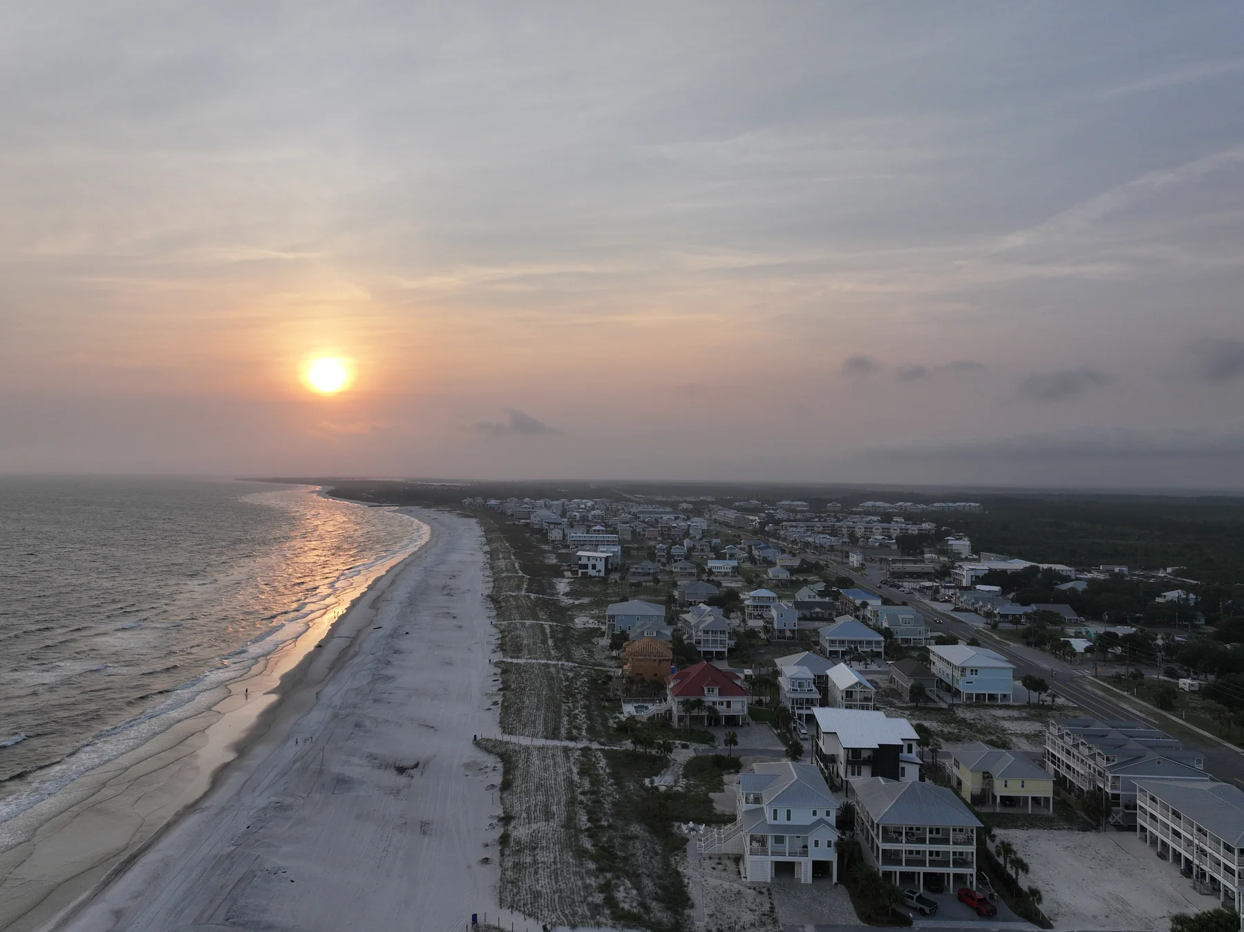
Cape San Blas From the Air: A Drone Pilot's Guide to Florida's Sunset Coast
A cape that faces the sunset, a bay you can read from two hundred feet, and a state-park drone rule almost nobody knows. Here's how a Part 107 pilot looks at Cape San Blas and Port St. Joe — and why this coast rewards aerial photography like almost nowhere else in Florida.
The Beach Run That Faces the Sunset
Look at Cape San Blas on a chart and it barely makes sense: a hook of sand jutting into the Gulf, with the St. Joseph Peninsula running about fifteen miles north of it like a raised arm. The Gulf sits on the west side of that arm and St. Joseph Bay on the east — which means the beaches here face west, and the sun goes down over open water. On most of Florida's Gulf coast the shoreline faces south; on the Atlantic side, sunrise is the show. On the cape, every clear evening ends with the sun dropping straight into the Gulf, and the rental porches are pointed right at it.
The spit is narrow — around half a mile wide in places — so from a couple hundred feet a drone can put both shorelines in one frame: Gulf surf on one side, the calm, seagrass-green bay on the other, and a single row of houses on the sand between them. There's no other frame like it on this coast, and it's exactly the kind of picture that made this beach famous — the state park at the peninsula's tip was ranked the #1 beach in America by "Dr. Beach" back in 2002, praised for sugar-white sand and the absence of overdevelopment. That second part still holds: county building and density rules keep the cape low-rise, so the skyline is dunes and rooflines, not towers.
Why the Cape Rewards a Drone More Than Most Places
Everything a guest wants to know about a Cape San Blas rental is spatial. How close is the sand? Is there a private boardwalk? What's actually behind the house — Gulf, bay, or scrub? Can we bring the dog? Ground photos answer none of that convincingly; a handful of honest aerials answers all of it in seconds. One frame shows the boardwalk from deck to dune. One top-down shows the house, the pool and the porch-to-water distance. One wide shot shows the thing money can't buy elsewhere in Florida: a beach with room on it. Leashed dogs are welcome on the cape's beaches outside the state park, which is a genuine booking filter — plenty of guests choose this coast for exactly that, and a photo of all that open sand makes the case without a word.
Here's the part that matters if you already have a listing: much of the Cape San Blas aerial footage floating around online was shot in 2017 and 2018 — before and right after Hurricane Michael. The storm cut the peninsula clean through about a mile north of the state park entrance; the breach has since been filled and stabilized, the dunes were rebuilt with a beach renourishment project, and the park's campground reopened in late 2023 after a five-year rebuild. The cape in those old clips isn't the cape that's there now. Fresh aerials aren't a nice-to-have here — they're the difference between showing guests the rebuilt coast or a memory of it. I made the same point about Mexico Beach after its beach renourishment, one town up the road: this shoreline keeps changing, and photos age faster here than almost anywhere.
The sunset photo at the top of this post is mine, from a July evening flight at Mexico Beach — the same stretch of coast, twenty minutes up US-98. Cape San Blas is squarely inside the run I cover from Panama City Beach to the Forgotten Coast, and it's next on my list to shoot for the portfolio.
The State-Park Rule Almost Nobody Knows
T.H. Stone Memorial St. Joseph Peninsula State Park owns the top of the peninsula — the wilderness preserve, the famous beach, Eagle Harbor on the bay side. And here's what surprises almost everyone: Florida's state park rules prohibit any aircraft, drones included, from taking off or landing anywhere inside a state park. That's not a Cape San Blas quirk; it's statewide administrative code, and as of August 2026 no Florida state park has a designated launch site open to visitors. The airspace overhead is federal — the FAA governs what flies over the park — but the ground is the state's, so a legal shoot near the park means launching from outside the boundary and planning the whole flight around that line.
Practically, that rule splits the cape in two. Rental rows and private property along the C-30 corridor and the lower peninsula: normal flying, launched from the property with the owner's blessing. The park itself: no launching, no landing, no promises — from me or anyone else you hire. One more line on the chart worth knowing: the Air Force still holds land at the far tip of the cape, a legacy tracking site, and I treat that property as off-limits the same way I treat the Tyndall fence line near Mexico Beach. If a drone operator you're vetting doesn't know either of those boundaries, keep vetting.
The Airspace, From a Pilot's Chair
The flying itself is about as clean as Florida gets. Cape San Blas and Port St. Joe sit in uncontrolled Class G airspace at drone altitudes — no towered airport, no LAANC grid, nothing to request for a Part 107 flight at or below 400 feet. The two things I actually watch: little Costin Airport a couple of miles south of downtown Port St. Joe, a non-towered field that now hosts both manned and unmanned operations, which earns real see-and-avoid discipline nearby; and the military warning areas offshore, which begin three nautical miles out over the Gulf — live training airspace that shore-based property work never touches, and a good reason not to chase a shrimp boat toward the horizon. All of that checked against FAA data as of August 2026; boundaries and NOTAMs change, so B4UFLY and a NOTAM check open every flight, every time.
Port St. Joe: The Working Waterfront Next Door
The cape gets the postcards, but Port St. Joe is where this coast does business — and it photographs beautifully from the air. Reid Avenue, the historic downtown strip a block off Highway 98, has come back strong since Hurricane Michael: locally owned storefronts, sidewalk tables, a farmers' market twice a month. The marina the storm destroyed was rebuilt and reopened in late 2022 as Point South Marina, and the bayfront at George Core Park runs shallow and glass-clear for hundreds of feet — from altitude, the bay grades from sand to seagrass like a paint swatch. Standing over it all is the Cape San Blas Lighthouse itself, which erosion chased off the cape; the whole tower and its keepers' quarters were moved downtown in 2014, and you can climb it today.
There's also a working story here for builders: between St. Joe Beach and WindMark Beach, the corridor north of town is in the middle of an active construction run — master-planned neighborhoods filling in, national builders on site, rebuilds still landing. That's exactly the use case for monthly drone progress video — the same flight line, month after month, showing lots become streets and streets become neighborhoods. And for everything a rental owner needs on this coast — covers, aerials, walkthroughs, twilight — the full stack is on my vacation rental photography and video page, with the local details on my Port St. Joe & Cape San Blas page.
Timing a Shoot on This Coast
West-facing beaches make scheduling simple: the last two hours of light, ending with the sun over open water, are the money window for exteriors and aerials — true golden hour into a genuine over-water sunset, the thing most Florida Gulf towns can't quite offer. Interiors shoot best midday and don't care about orientation. And right now the bay adds its own show: the St. Joseph Bay scallop season runs August 16 through September 24 this year, which means clear shallows dotted with boats and snorkelers — a working, living bay in every wide frame, and rental calendars full of the guests those photos are for. If your listing needs to be ready for next season instead, fall and winter give empty beaches, soft light and turnover gaps that make scheduling easy. Either way, listing shoots come back with next-day delivery, so a fresh gallery never waits on me.
Questions owners ask about this coast
Not from inside it. Florida's state park rules prohibit any aircraft — the Park Service applies this to drones — from taking off or landing anywhere in a state park, and as of August 2026 no Florida state park has a designated launch facility open to visitors. The airspace overhead is a separate, federal matter, so a shoot near the park means launching legally from outside the boundary and planning the flight from there. Be wary of anyone who promises takeoffs from inside the park.
For a Part 107 flight at or below 400 feet, no — this is uncontrolled Class G airspace with no LAANC grid to request. Two things still earn attention: little Costin Airport just south of downtown Port St. Joe hosts both manned and unmanned traffic, so flights near it call for extra vigilance, and the offshore military warning areas begin three nautical miles out over the Gulf, which shore-based property work never approaches. Airspace facts checked as of August 2026 — a preflight B4UFLY and NOTAM check is still part of every flight.
Downtown Port St. Joe. The 1885 iron skeletal tower spent its working life on the cape, but erosion kept taking the ground out from under it, and in 2014 the tower and its two keepers' quarters were moved to George Core Park on the bayfront, where you can climb it today. It's one of the best photo subjects in town — and a pretty honest symbol of how fast this shoreline changes.
Next-day delivery for vacation rental and real estate listing shoots — photographed one day, in your listing the next. Travel to the cape is already in the quote, I'm an FAA-certified drone pilot under Part 107, insured, and a certificate of insurance is available on request.