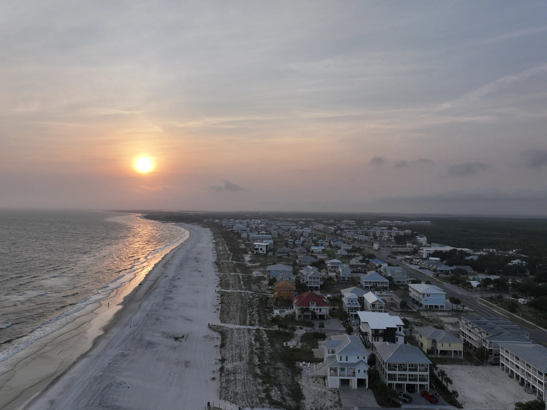
Mexico Beach From a Couple Hundred Feet: Vacation Rental and Drone Photography Notes From a Sunset Flight
I flew the Mexico Beach coastline at sunset on July 28 — no client, no deadline, just the Gulf going copper behind rows of beach houses. Here's what this town looks like from the air, and why vacation rental listings here deserve better than phone photos.
What Mexico Beach Looks Like From a Couple Hundred Feet
On the evening of July 28 I stood on the public beach at Mexico Beach — 29.9459 north, 85.4161 west, if you want the exact spot — and sent the drone up as the sun dropped toward the Gulf. Nobody hired me for the flight. I wanted this coastline in my portfolio, and a Mexico Beach sunset is worth the drive on its own.
From a couple hundred feet, the town explains itself. Rooflines stay low in every direction — rows of beach houses, a handful of small motels, a wide ribbon of white sand, and then nothing but water going copper and rose all the way to the horizon. No towers, no cranes, no condo canyon throwing shadows on the beach by late afternoon. For a drone pilot, it's an uncluttered frame. For a rental owner, it's an opening most phone galleries can't touch.
A Town That Voted to Stay Small
Mexico Beach sits about 25 miles southeast of Panama City on US 98, with Port St. Joe roughly 12 miles farther east. About a thousand people live here. Tourism writeups pitch it as the smaller, quieter sibling of the beach towns to the west — a place without chain restaurants or high-rise hotels — and the local tourism council brands this stretch The Unforgettable Coast. None of it is accidental: building heights have long been capped at 32 feet residential and 48 feet commercial, and in April 2024 residents voted, 74 percent in favor, to lock those caps into the city charter. Roughly three residential stories, maximum — and since then it takes a public vote to raise that.
That choice shapes where guests sleep. Lodging here mostly means a rental beach house, plus a few vintage motels like the Driftwood Inn and the El Governor. So if you own a vacation rental in Mexico Beach, your competition is the house next door and the whole row past it — and from the seaward side, the rows look remarkably alike: similar heights, similar pilings, similar porches. On a booking site, thumbnails flatten them even further. The photos are the difference, because not much else visibly is.
The Beach in Your Old Photos Isn't the Beach That's There Now
Some history is visible from the air. Hurricane Michael came ashore here on October 10, 2018 as a Category 5 with 160 mph winds — the first Cat 5 to hit the U.S. mainland since Andrew in 1992. Storm surge of up to about 14 feet moved through town, more than 800 buildings were destroyed, and FEMA's administrator called Mexico Beach ground zero. The town has spent the seven-plus years since rebuilding, house by house. The pier is the big piece still missing: its replacement, named for the late Al Cathey, the mayor who led the town through Michael and its rebuild, is funded through FEMA and cleared its environmental review in April 2026 — inching toward construction, not there yet.
Then, in 2025, the shoreline itself got rebuilt. A beach nourishment project placed nearly a million cubic yards of sand along the town's shoreline — the dune rebuilt on the west end, and from about 34th Street east, the berm pushed roughly 175 feet farther toward the Gulf. It wrapped up on April 12, 2025. Read that as a rental owner: if your house sits along that stretch and your listing photos are more than a year old, the beach in front of it is measurably wider than the one in them. Old imagery undersells the single thing guests come for — I went deeper on fixing tired galleries in my Mexico Beach Airbnb listing photos post.
Straight-down aerials make the case fastest. One top-down frame shows the pool, the deck, the walkover, and the honest porch-to-water distance — the things guests squint at in a gallery, trying to figure out.
The Chart Work Next Door: Drone Rules Beside Tyndall
Here's the part of a Mexico Beach shoot guests never see. The town itself sits in uncontrolled Class G airspace at drone altitudes — there's no LAANC grid overhead and nothing to request for a Part 107 flight at or below 400 feet. What makes this a chart-check town is what sits next door. Tyndall Air Force Base starts a few miles west of the city limits, and everything over base property is a federal no-drone zone — the FAA security restriction runs from the surface to 400 feet, which is the entire band a Part 107 flight lives in. On the sectional, restricted areas R-2905A and B sit just southeast of Tyndall, over Crooked Island and the Gulf, surface to 10,000 feet, activated by NOTAM — sometimes in short windows while the base launches and recovers its own unmanned aircraft. None of that covers Mexico Beach, but it's close enough that B4UFLY and a NOTAM check are part of my preflight here, every time.
The sunset part is simply legal. Up to official sunset is daylight flying; the 30 minutes after are what Part 107 calls civil twilight, which requires an anti-collision strobe visible for three statute miles. Mine runs the whole flight regardless. Two more lines worth knowing on this coast: Florida state parks don't allow drones to launch or land inside park boundaries — that takes St. Joseph Peninsula off the table — but Mexico Beach's public beach is city beach, not a state park. And Class G doesn't mean anything goes: I keep the aircraft off sunbathers, and posted shorebird nesting areas get the same wide berth I give the Tyndall fence line.
Airspace facts above were checked against FAA data as of July 2026. Boundaries and NOTAMs change, so whoever flies your property should verify both on shoot day — asking how they handle the Tyndall side is a fair test of anyone you're considering.
What a Vacation Rental Owner Should Actually Order
A ground photo set first. Interiors shot level and bright, exteriors timed to the light — on this stretch the Gulf faces roughly south, so the good exterior window is the last two hours before sunset, the same light I was flying in on July 28. This set fills the gallery on Airbnb, Vrbo, or a direct-booking site and does most of the daily work.
A drone set second. Six to ten aerials: the house in its row, a top-down of the pool and deck, and the one frame that shows the walk to the sand. In a town capped at roughly three residential stories, aerials also show something rare — a horizon with nothing stacked in front of it.
A short vertical video third. Fifteen to thirty seconds cut for Reels and TikTok, pulled from the same flight as the stills. One session can feed the listing, the social accounts, and a manager's website without booking three separate shoots. How I put these pieces together is laid out on my vacation rental photography and video page.
Grand Ridge to Mexico Beach: An Hour Up the Road, Travel Included
I'm based in Grand Ridge, about an hour north of Mexico Beach, and this coastline is home ground, not a road trip. Travel's always in my quotes — one number, and the drive down to the coast is my problem, not yours. I'm an FAA-certified drone pilot under Part 107, insured, with a certificate of insurance available on request. If you want the town-specific details, my Mexico Beach page has them, and my coastal media hub covers the whole run from Panama City Beach to Cape San Blas.
If you own or manage a vacation rental here and the listing photos haven't kept up with the town — the new sand, the rebuilt streets, the way the light lands on a July evening — send me the listing link. I'll tell you honestly what's worth reshooting and what isn't, and we can go from there.
Questions rental owners actually ask
Golden hour up to official sunset is regular daylight flying under Part 107. From sunset to 30 minutes after is civil twilight — also legal without a waiver as long as the drone runs anti-collision lighting visible for at least three statute miles. Later than that counts as night, which has been legal without a waiver since the 2021 rule change, provided the pilot is current on the updated night training and the strobe stays on.
For exteriors and aerials, the last two hours before sunset: the Gulf faces roughly south here, so evening light rakes along the shoreline instead of blasting straight into the lens. Interiors are more forgiving and usually look best midday with every light on. A typical shoot covers interiors first, then moves outside as the light drops.
Often they help more. An aerial shows how far the house actually sits from the water — one of the first things guests try to work out from a gallery. And because Mexico Beach caps homes at roughly three stories, one frame from altitude shows an open horizon that ground photos can't. I went deeper on the low-rise argument in my Mexico Beach Airbnb photos post.
The same standard you'd set for a guest arrival: beds made, counters clear, pool and deck tidy, outdoor furniture set out, bulbs working. If the house is on a rental calendar, we schedule inside a turnover gap. Send your listing link ahead of time — it tells me what you have, what's missing, and which shots will actually move bookings.